 Loading... Please wait...
- Home
- Products
- Tiltmeters · Pendulums
- GeoNet Wireless Mesh Tilt Loggers
Products
Tiltmeters · Pendulums
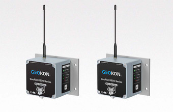
GeoNet Wireless Mesh Tilt Loggers | 8800 · 8900 Series Tilt Loggers
The 8800 and 8900 Series Mesh Tilt Loggers combine the capabilities of a biaxial tiltmeter with a wireless GeoNet Mesh Logger. The self-contained tilt loggers are attached to various structures including dams, embankments, foundation walls, retaining walls, buildings, etc., and provide wireless measurement of any tilting that may occur. Remote access of sensor data is achieved via the Cellular Gateway,¹ which controls the mesh network and collects sensor data from any tilt loggers deployed. A Local Gateway, without cellular capabilities or cloud integration, provides the same control over the network to allow secure, localized access to your sensor data.
Seamless and secure cloud integration is achieved with GEOKON OpenAPI. The GEOKON OpenAPI portal is easy-to-use and allows users to activate loggers, change settings, configure sensor channels, and view current logger status. Industry leading data visualization software, or the no-cost GEOKON Agent Software, can be used with GEOKON OpenAPI for data viewing and reporting.
In addition, Solar Panels of various wattages are available for use with these Tilt Loggers.
For more information about the full complement of GeoNet Wireless Mesh Loggers, please see the GeoNet 8800 and 8900 Series.
8900 Series
- Data Sheet ›
- Quick Start Guide ›
- Quick Start Guide (pdf) ›
- Manual ›
- Manual (pdf) ›
- Firmware Update ›
- Guía de inicio rápido ›
- Guía de inicio rápido (pdf) ›
- Manual de Instrucciónes ›
- Manual de Instrucciónes (pdf) ›
- Kurzanleitung ›
- Kurzanleitung (pdf) ›
- Bedienungsanleitung ›
- Bedienungsanleitung (pdf) ›
- Tutorials (pdf) ›
- Tutorial Videos ›
- Agent Software Manual ›
- Agent Software (x64) ›
- Agent Software (x86) ›
- Agent Tutorial Videos ›
8800 Series
¹GeoNet Cellular Gateways are compatible with all major networks except Verizon.
Specifications
902-906, 915-928 MHz (Brazil)
915-928 MHz (Australia, Chile, Peru)
863-870 MHz (Europe)
8900 | Up to 22 km (5.5 km × 4 hops) (Europe)
8800 | Up to 26 km (6.5 km × 4 hops) (all models)
(range varies by power source)
¹Outdoor, clear line-of-sight, maximum 4 hops.
²Calibrated range: ±30°
³99% confidence interval (i.e. 99 out of 100 individual readings fall within this tolerance).
⁴99% confidence interval. Includes random walk (changes between consecutive readings that have no discernible cause) and seismic noise during testing.
GEOKON offers a variety of Custom Tiltmeter and Pendulum options and members of our experienced staff will help with the modifications necessary to meet your specific requirements. To learn more, please visit:
Please Note: GEOKON maintains an ongoing policy of design review and reserves the right to amend products and specifications without notice. Various instruments are discontinued over time and replaced with new, updated models.
